
We've invested £2.8 million in a new pipeline through Sevenoaks to secure the drinking water supply to the town for years to come.
The new three-kilometre main supports the existing pipe which runs through Sevenoaks High Street.
Without this project, population growth would have resulted in parts of the town having no drinking water or low pressure within the next ten years, every morning and evening when demand is highest.
There was also the risk that the existing pipe would have been pushed beyond its design limit and suffer from bursts.
The new pipeline runs from our drinking water storage tank on Tonbridge Road to the junction of Dartford Road and Avenue Road and feeds more water into the two and meet the daily peak demand for water.
The project started in July 2020, but engagement with the local community began more than two years before we started laying the first pipe. This was due to the highly congested town centre bordered by a privately owned park which is open to the public and a Site of Special Scientific Interest.
We held extensive consultations with stakeholders and the public to determine the best route possible for the new main, with three public consultation events held to gather feedback on four potential route options.
In total, 158 individuals attended our public exhibitions in December 2018, with 90 feedback forms completed, while we also consulted with local interest groups and landowners, writing to more than 9,500 Sevenoaks residents and speaking to 168 businesses in the High Street.
We also held a round-table discussion meeting on 18 January, 2019, chaired by the MP at the time, Sir Michael Fallon.
Following this meeting, stakeholders agreed that the routes through the High Street and around the outskirts of the park should not be investigated further as they would not be completed before residents may experience low pressure or loss of tap water supply at peak times.
We held a further community drop-in session in September 2019 to give the public the chance to speak to our engineers again, with 116 people attending the event and 94 per cent of people completing feedback forms agreeing that the route option chosen was the preferred option.
As such, phase one of the water main was installed during the summer of 2020, with the work taking place in the Hollybush area and the A225 (Tonbridge Road) and between these two points.
The second phase started in March 2021 to lay the remaining 2.2 kilometres of new water main through Knole Park, with some work taking place in the surrounding roads.
Key milestones:
- December 2018 – Three public consultation events held to try and determine the best route possible
- Friday, 18 January, 2019 – Round-table meeting held, chaired by Sir Michael Fallon
- Thursday, 12 September 2019 – Selected route announced at public information evening at St Nicolas Church Undercroft
- February 2020 – Trial holes undertaken to determine the best route for the pipe to follow in the road
- June 2020 – Work started with a road closure in Avenue Road (western side) and in the A225 (Tonbridge Road), south of Knole Park
- September 2020 – Work completed on the first phase of work in Hollybush Close and Tonbridge Road A225
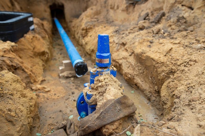
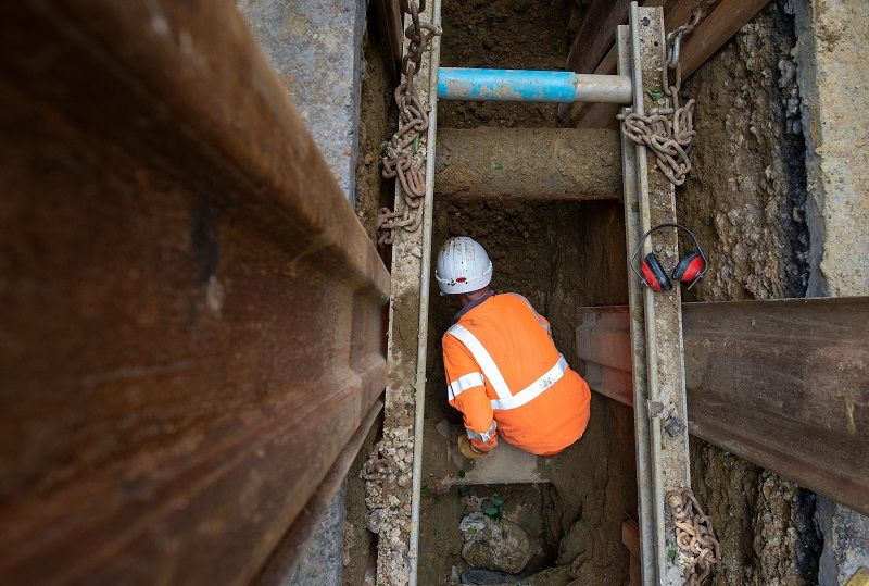
Pictures:
Here are a few pictures showing our work in Hollybush Close and Tonbridge Road A225:


- April 2021 – Work started on the second phase of the project, into Knole Park from the Tonbridge Road (A225)
- August 2021 – Work completed on laying water main in the second phase of the project
- October 2021 – Project completed with the new main in service following testing in September
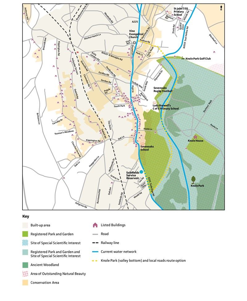
Knole Park
Route through Tonbridge Road, through Knole Park (valley bottom / the Gallops), drilling underneath Seal Hollow Road, then along Hollybush Close and Avenue Road.
While in the park we used a technique called directional drilling, which involves digging two launch and receive holes in the ground and then we drill the pipe between these underground. This process is less damaging to the grasslands than more traditional techniques such as open trenching.

Comparison of key factors for each route option
| High Street | Knole Park and local roads | Sevenoaks School and Knole Park | East of Knole Park | |
|---|---|---|---|---|
| Cost (excluding compensation) | £3.9 million | £1.8 million | £1.9 - £2.8 million | £7.5 million |
| Pipe length | 1.8 kilometres | 2.9 kilometres | 2.6 kilometres | 9.5 kilometres |
| Work duration | Up to 10 years | Within one year | Potentially two years | Potentially 20+ years |
| Traffic management | Lane closures / road closures on A225 | Traffic lights on A225. Hollybush Close and Avenue Road closed in sections. | Traffic lights on A225. Hollybush Close and Avenue Road closed in sections. | Road closures on Seal Hollow Road, St Julians Road, Park Lane and Blackhall Lane. Traffic lights on A225. |
| Environmental | Listed buildings. Potential archaeology. | Within a SSSI but the special features will not be impacted by work. Potential archaeology. | Within a SSSI but the special features will not be impacted by work. Potential archaeology. | Listed buildings and potential archaeology. Partly within a SSSI but special features won’t be impacted. |
| Socio-economic | Busy high street, heavy commuter traffic, independent shops impacted | Knole Park would stay open throughout, minimal disruption. | Use of rugby pitches restricted at the school for one year. Little impact on Knole Park. | Increased congestion and pollution in other parts of town during road closures. Access to various schools affected. |
| Technical difficulty | Lots of other utilities in the ground to weave the pipe around | We already have an 18-inch main in this part of the park. The ground is suitable for either open cut or horizontal directional drilling constructions techniques. | Ground investigations showed that there is a risk of directional drilling fluids breaking through the ground. An open cut method would have a greater impact on the school, and on the environment within Knole Park. | A larger pipe and additional pumping stations needed due to the pipe length. |
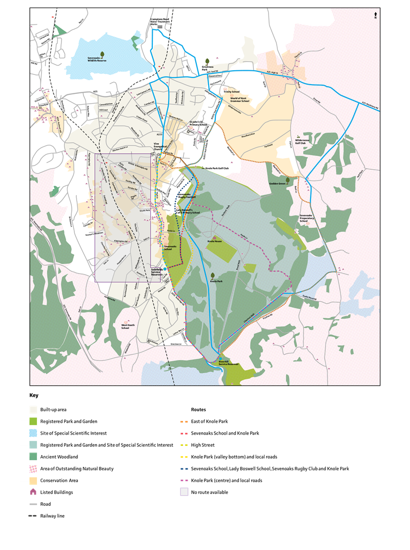
All routes
The map below shows all the routes we considered for the new pipe.
The selected route was:
- Knole Park and local roads
The following routes were ruled out for technical reasons, as our research showed that it was not practical to lay a water pipe or because the pipe would not be commissioned before residents experienced low tap water pressure or no water at all.
- Knole Park centre
- Sevenoaks School, Lady Boswell School and Knole Park
- There was no suitable route for a water main in the residential area west of the high street because we would have to cross the railway line at the London Bridge overbridge which is technically complex, expensive and would cause congestion on a very strategically important road.
- High Street
- East of Knole Park
- Sevenoaks School and Knole Park
The map also shows the environmental features of this area, including the Area of Outstanding Natural Beauty, Conservation Area, Site of Special Scientific Interest, Ancient Woodland, Registered Parks and Gardens and Listed Buildings.

You can read all about our consultation, including our public events and how the route was selected in our report below.
Share this Article: